Light Detection and Ranging LiDAR image shows the archaeological mounds in this restored wetland in Illinois. NRCS photo.
Sometimes to stop soil erosion, prevent nutrient and sediment runoff and improve habitat, conservation work does disturb the ground. Because of this, USDA’s Natural Resources Conservation Service relies on its archaeologists on staff to review locations prior to implementing these conservation practices. As the cultural resources specialist for NRCS in Illinois, I’m never quite sure what will turn up in my daily work.
Field investigations by NRCS archaeologists are conducted to look for surface indications of cultural resources, such as historic farm remains, prehistoric artifacts and above-ground structures. I have had opportunities to visit about 2,000 archaeological sites and to record about 400 new sites on private working lands throughout the state.
One of our truly successful programs is the Agricultural Conservation Easements Program, which takes sensitive wetland areas out of crop production and restores the natural habitat.
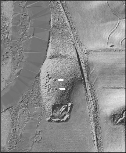
Along the Pecatonica River in Stephenson County is a 270-acre wetland easement we call Duck’s Misery. During a site inspection, NRCS District Conservationist Jim Ritterbusch noticed two doughnut-shaped earthen structures in the wooded area on a bluff spur adjacent to a backwater slough.
When he sent the location of the easement for my review, I consulted the Illinois archaeological site files. Not long after, our soil scientist and I visited the site with Ritterbusch to see the structures. The two circular prehistoric Indian burial mounds were identical in size and matched the dimension on the site form.
Also, as described on the site form, both were badly vandalized with huge central craters. Most mounds in the United States are looted for their artifacts, such as prehistoric pottery, copper axes, shell jewelry and human remains. Early settlers dug into them, but this kind of vandalism still occurs today. The site form did not mention that there were two mounds, and the mapping of the mounds was incorrect.
Frank Heisner, a soil scientist with NRCS, brought along a copy of the light detection and ranging (LiDAR), map for this easement. Our field offices, in counties where LiDAR mapping is complete, have access to the maps from their USDA computers.
For those of you unfamiliar with this new mapping technology, LiDAR is a remote sensing method that uses light in the form of a pulsed laser to measure ranges to the earth. A LiDAR instrument principally consists of a laser, a scanner, and a specialized global positioning system, or GPS receiver. Most often, airplanes and helicopters are used for LiDAR mapping.
In short, when an airborne laser is pointed at a targeted area on the ground, the beam of light is reflected by the surface it encounters, and a sensor records this reflected light to measure a range. When the laser ranges are combined with position and orientation data generated from the GPS, the result is a dense, detail-rich group of elevation points. It can even measure the elevations through tree canopy.
With this LiDAR image, I could correct the location of the site and with our on-site revisit, I could add new information to the Illinois archaeological site files.
Cultural sites like this do restrict some conservation practices. We would not plant trees on top of burial mounds or remove invasive trees by pulling them out by the roots. We would promote grass cover on the mounds and any trees would be above ground removed by hand.
With the use of LiDAR imaging, archaeologists can scan the landscape for structures yet unrecorded and correct inaccurate site mapping. The more information we have, the better we can implement conservation, like enhancing this wetland, as well as protect sensitive ecological and cultural landscapes for future generations.

Frank Heisner and Jim Ritterbusch sit alongside the crater of the former historical mounds. NRCS photo.


